WARNING:
JavaScript is turned OFF. None of the links on this concept map will
work until it is reactivated.
If you need help turning JavaScript On, click here.
Este Cmap, tiene información relacionada con: 8. Mapa topográfico, el TAMAÑO del MAPA y el TAMAÑO REAL del TERENO se puede expresar de forma GRÁFICA, el TAMAÑO del MAPA y el TAMAÑO REAL del TERENO se puede expresar de forma NUMÉRICA, ELEMENTOS SUPERFICIE TERRESTRE puede que hechos a ESCALA, CURVAS de NIVEL (=ISOCOTAS) se caracteriza por 1) SER LÍNEAS CERRADAS, 2) CORRELATIVAS y EQUIDISTATES, y 3) SU SEPARACIÓN es PROPORCIONAL a la PENDIENTE, ESCALA es la relación entre el TAMAÑO del MAPA y el TAMAÑO REAL del TERENO, ELEMENTOS SUPERFICIE TERRESTRE se representa mediante SÍMBOLOS, RELIEVE se representa mediante CURVAS de NIVEL (=ISOCOTAS), MAPA TOPOGRÁFICO es una REPRESENTACIÓN GRÁFICA, PLANA y a ESCALA, MAPA TOPOGRÁFICO hay ????, ???? debidamente ORIENTADOS Y UBICADOS, RELIEVE hechos a ESCALA, GRÁFICA e.g, REPRESENTACIÓN GRÁFICA, PLANA y a ESCALA del RELIEVE, REPRESENTACIÓN GRÁFICA, PLANA y a ESCALA del ELEMENTOS SUPERFICIE TERRESTRE, NUMÉRICA e.g 1: 5000
isolíneas
Cuál son las isolíneas verdaderas
Actividad de escala y coordenadas
Coordenadas de la Península Ibérica
Mapas y coordenadas
Brújula
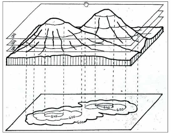
Pasar mapa topográfico a 3D
Pasar de 3D a mapa topográfico
Actividad de escala mapa topográfico
Coordenadas geográficas
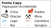
Símbolos
Cómo levantar un perfil topográfico
perfil topográfico y montaña rusa
Mapa topoográfico
Qué es el mapa topográfico